The giant Borganism that is the federal government has a built-in bias to stick its tentacles into every orifice of the body politic, gathering more money, power and influence to itself in stark defiance of the Founder’s blueprints for a weak federal government checked by strong state and citizen sovereignty. In addition to money and power, it also wants to gobble up land, and now it wants to eat 700,000 acres of private land on Texas-New Mexico border.
Under the guise of “land protection,” the federal government aims to acquire 700,000 acres of private land in the Southern High Plains region—which sits along the Texas-New Mexico border.
The U.S. Fish and Wildlife Service recently finalized its Land Protection Plan. The plan aims to acquire 700,000 acres of privately owned land and put it under federal control for “protection” in “perpetuity.” This is part of the federal government’s efforts to expand the Muleshoe National Wildlife Refuge—which feeds into the broader aim of the Biden administration: fulfilling the “30×30” initiative.
Through the “30×30” initiative, the Biden administration decided that 30 percent of the nation’s land and waters must be under federal control and management by 2030. President Biden launched the agenda via Executive Order 14008 on January 27, 2021.
However, American Stewards of Liberty explains that the initiative was rebranded as “America the Beautiful” after facing public backlash.
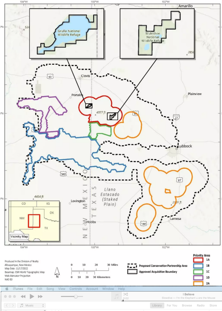
As the American Stewards highlight, the Muleshoe National Wildlife Refuge is attempting to expand the “acquisition boundary” from 6,440 acres in Texas and New Mexico to 7,000,000 acres—all without congressional authority. After they acquire more land, they plan to federalize 700,000 acres through buying the land or obtaining permanent conservation easements.
“Federally acquiring nearly three-quarter million acres from this region is a direct attack on the oil, gas, and mineral industries, agriculture production, and local economies,” the American Stewards write.
They also claim counties were not notified of the expansion.
“No direct notice was given to the counties or local governing authorities. The USFWS [U.S. Fish and Wildlife Service] failed to coordinate this plan with the local governments as required by law.”
The expanded area grabs land in 15 Texas counties including Bailey, Castro, Cochran, Crosby, Dawson, Gaines, Garza, Hale, Hockley, Lamb, Lubbock, Lynn, Parmer, Terry, and Yoakum. The expansion into five counties in New Mexico includes land from Chaves, Curry, De Baca, Lea, and Roosevelt counties.
If you look at a map of the proposed takings, you can see federal environmentalists want to “conserve” (i.e. control) land rightup to the edge of Lubbock:

Both this plan and the 30×30 plan in general smack of the sort of unauthorized, self-directed bureaucratic empire-building that the Loper Bright Enterprises v. Raimondo decision struck down. Both private land owners and the State of Texas should resist this blatant land grab with all the tools at their disposal.